How Many States in India? All 28 States & 8 Union Territories Explained
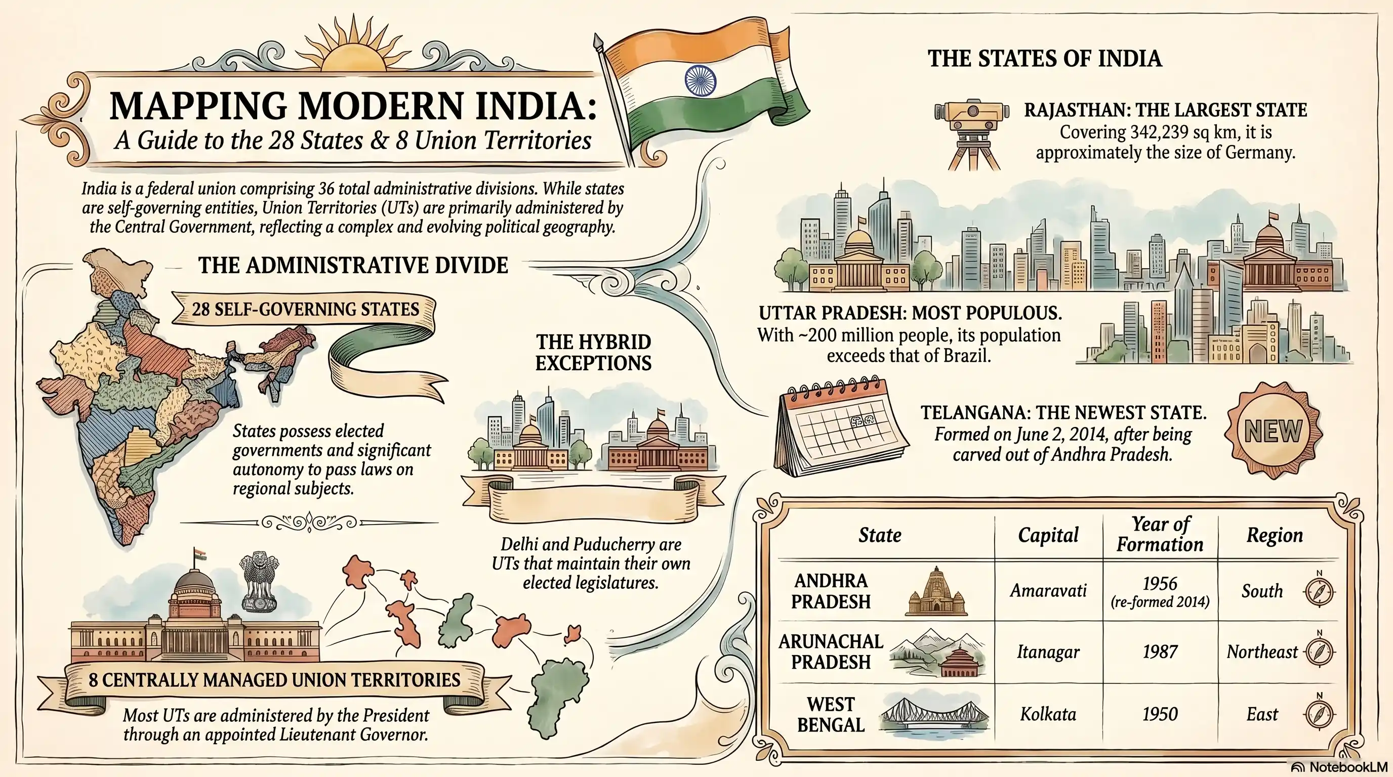
India currently has 28 states and 8 Union Territories, making it one of the most complex federal structures in the world. The states are fully self-governing with elected governments, while Union Territories are administered either directly by the Central Government or through a lieutenant governor. Together, they cover a country of 1.4 billion people spread across 3.29 million square kilometres.
How Many States Does India Have Right Now?
As of 2026, India has:
- 28 States
- 8 Union Territories
That adds up to 36 administrative divisions in total.
This wasn't always the count. India's internal map has been redrawn multiple times since independence new states have been carved out, Union Territories have been upgraded, and some have been reorganised entirely. The most recent major change came in 2019, when Jammu & Kashmir was reorganised into two separate Union Territories: Jammu & Kashmir and Ladakh.
Complete List of All 28 States of India
Here's the full list of every state in India, with its capital, the year it achieved statehood in its current form, and the region it belongs to.
| S.N. | State | Capital | Year of Formation | Region |
|---|---|---|---|---|
| 1 | Andhra Pradesh | Amaravati | 1956 (re-formed 2014) | South |
| 2 | Arunachal Pradesh | Itanagar | 1987 | Northeast |
| 3 | Assam | Dispur | 1950 | Northeast |
| 4 | Bihar | Patna | 1950 | East |
| 5 | Chhattisgarh | Raipur | 2000 | Central |
| 6 | Goa | Panaji | 1987 | West |
| 7 | Gujarat | Gandhinagar | 1960 | West |
| 8 | Haryana | Chandigarh | 1966 | North |
| 9 | Himachal Pradesh | Shimla | 1971 | North |
| 10 | Jharkhand | Ranchi | 2000 | East |
| 11 | Karnataka | Bengaluru | 1956 | South |
| 12 | Kerala | Thiruvananthapuram | 1956 | South |
| 13 | Madhya Pradesh | Bhopal | 1956 | Central |
| 14 | Maharashtra | Mumbai | 1960 | West |
| 15 | Manipur | Imphal | 1972 | Northeast |
| 16 | Meghalaya | Shillong | 1972 | Northeast |
| 17 | Mizoram | Aizawl | 1987 | Northeast |
| 18 | Nagaland | Kohima | 1963 | Northeast |
| 19 | Odisha | Bhubaneswar | 1950 | East |
| 20 | Punjab | Chandigarh | 1966 | North |
| 21 | Rajasthan | Jaipur | 1956 | North |
| 22 | Sikkim | Gangtok | 1975 | Northeast |
| 23 | Tamil Nadu | Chennai | 1950 | South |
| 24 | Telangana | Hyderabad | 2014 | South |
| 25 | Tripura | Agartala | 1972 | Northeast |
| 26 | Uttar Pradesh | Lucknow | 1950 | North |
| 27 | Uttarakhand | Dehradun | 2000 | North |
| 28 | West Bengal | Kolkata | 1950 | East |
Note on Chandigarh: Both Punjab and Haryana list Chandigarh as their capital. Chandigarh itself is a Union Territory and serves as a shared capital for both states a unique arrangement in India's federal setup.
Note on Hyderabad: Hyderabad is listed as the capital of Telangana. It was also the capital of Andhra Pradesh until 2 June 2024, when Amaravati formally became Andhra Pradesh's capital.
Complete List of All 8 Union Territories of India
Union Territories are a different category altogether more on that distinction below. Here are all eight:
| S.N. | Union Territory | Capital / HQ | Region |
|---|---|---|---|
| 1 | Andaman and Nicobar Islands | Port Blair | Islands (Bay of Bengal) |
| 2 | Chandigarh | Chandigarh | North |
| 3 | Dadra and Nagar Haveli and Daman and Diu | Daman | West |
| 4 | Delhi (NCT) | New Delhi | North |
| 5 | Jammu & Kashmir | Srinagar (summer) / Jammu (winter) | North |
| 6 | Ladakh | Leh | North |
| 7 | Lakshadweep | Kavaratti | Islands (Arabian Sea) |
| 8 | Puducherry | Puducherry | South |
Two of these Union Territories Delhi and Puducherry have their own elected legislatures and councils of ministers, which gives them limited self-governance. The other six are administered directly by a lieutenant governor or administrator appointed by the President of India.
What's the Difference Between a State and a Union Territory?
This trips a lot of people up, so let's break it down clearly.
States have their own elected governments. They have a Chief Minister, a Council of Ministers, and a State Legislative Assembly. States have significant autonomy they can pass laws on subjects listed in the State List of the Constitution, and they share power with the Centre on subjects in the Concurrent List.
Union Territories are administered by the Central Government. The President of India appoints an Administrator or Lieutenant Governor to run each UT. The Centre has much tighter control over day-to-day governance in Union Territories.
The practical difference for residents?
People in states elect their own government directly and have more localised control over issues like police, public health, and agriculture. People in most Union Territories (except Delhi and Puducherry) have less direct say, since ultimate authority rests with the Centre.
The constitutional basis for this comes from Articles 1 to 4 of the Indian Constitution, which define the country's territory and give Parliament the power to admit, form, or alter states and Union Territories.
How India's States Were Reorganised: A Brief History
India didn't arrive at 28 states overnight. The current map is the result of decades of political negotiation, linguistic activism, and administrative restructuring.
Independence and the First Map (1947–1950)
When India gained independence in 1947, the country was a patchwork of British provinces and over 500 princely states. Most princely states were integrated into the Indian Union by 1950, but the administrative divisions didn't yet reflect cultural or linguistic realities.
The States Reorganisation Act, 1956
This is the most important piece of legislation in understanding India's state structure. The States Reorganisation Act of 1956 redrew the internal boundaries of India primarily along linguistic lines. The Fazl Ali Commission had recommended this approach, and Parliament agreed.
As a result, 14 states and 6 Union Territories were created from the old British-era provinces and princely state groupings. States like Kerala, Karnataka (then Mysore), and Andhra Pradesh took shape in their recognisable modern form in this period.
The 1960s–1980s: New States Keep Coming
The reorganisation didn't stop in 1956. Major milestones include:
- 1960 — Bombay State was split into Maharashtra (Marathi-speaking) and Gujarat (Gujarati-speaking) following mass agitation.
- 1963 — Nagaland became India's 16th state, carved out of Assam.
- 1966 — Punjab was divided into Punjab (Punjabi-speaking) and Haryana (Hindi-speaking), with Himachal Pradesh also carved out as a separate entity.
- 1972 — Manipur, Meghalaya, and Tripura achieved full statehood. Mizoram and Arunachal Pradesh were formed as Union Territories.
- 1975 — Sikkim merged with India and became the 22nd state after a referendum.
- 1987 — Goa, Mizoram, and Arunachal Pradesh all became full states.
2000: Three New States at Once
On 1 November and 9 November 2000, three new states were created simultaneously a record:
- Chhattisgarh: Carved from Madhya Pradesh (1 November)
- Uttarakhand: Carved from Uttar Pradesh (9 November; originally named Uttaranchal, renamed in 2007)
- Jharkhand: Carved from Bihar (15 November)
All three were carved from larger, predominantly Hindi-speaking states, driven by demands from distinct regional communities who felt administratively neglected.
Telangana: India's Most Recent State (2014)
Telangana became India's 29th state on 2 June 2014. Telangana was carved out of Andhra Pradesh after decades of agitation by the Telangana movement, which argued that the region had been economically marginalised. Hyderabad, the former joint capital, remained Telangana's capital, with Andhra Pradesh given time to develop a new capital.
Ladakh: The Newest Union Territory (2019)
The most recent structural change came in August 2019, when the Government of India reorganised the state of Jammu & Kashmir. The Jammu and Kashmir Reorganisation Act, 2019 bifurcated the state into two Union Territories:
- Jammu & Kashmir with a legislature (like Delhi and Puducherry)
- Ladakh without a legislature, administered directly by the Centre
This reduced the total number of states from 29 to 28, while increasing Union Territories from 7 to 8.
The Newest State and the Newest Union Territory
- Newest state: Telangana, formed on 2 June 2014, when it was carved out of Andhra Pradesh. It's the 28th state in India's current count.
- Newest Union Territory: Ladakh, formed on 31 October 2019 following the reorganisation of Jammu & Kashmir. It's the only Union Territory in India with no elected legislature.
Know Your's Prime Ministers Name Complete List: Who Was the First Prime Minister of India? Name, Facts & History
India's Largest and Smallest States
By Area
Largest state: Rajasthan covers 342,239 square kilometres about the size of Germany and the Netherlands combined. It accounts for over 10% of India's total land area.
Smallest state: Goa is India's smallest state at just 3,702 square kilometres. It's roughly the size of the Indian city of Bengaluru's metropolitan area.
By Population (2011 Census)
Most populous state: Uttar Pradesh, with a population of approximately 200 million people (2011 Census). That number is projected to be even higher today larger than Brazil's entire population.
Least populous state: Sikkim, with just over 600,000 people. It's a small Himalayan state in India's northeast, and its population is smaller than many Indian cities.
For Union Territories, Lakshadweep is the least populous division in India with fewer than 65,000 residents, while Delhi is by far the most populous UT with a population exceeding 16 million (2011).
India's Regional Groupings
India's 28 states are broadly grouped into six regions. These groupings are geographical and cultural they don't have formal constitutional status, but they're widely used for planning, policy, and general reference.
North India
Jammu & Kashmir (UT), Ladakh (UT), Himachal Pradesh, Punjab, Haryana, Uttarakhand, Uttar Pradesh, Rajasthan, Delhi (UT), Chandigarh (UT)
This is the largest region by area and population. It includes the Indo-Gangetic Plain, the Himalayas, the Thar Desert, and the politically significant state of Uttar Pradesh.
South India
Andhra Pradesh, Telangana, Karnataka, Kerala, Tamil Nadu, Puducherry (UT), Lakshadweep (UT), Andaman and Nicobar Islands (UT)
South India is home to Dravidian languages Telugu, Kannada, Malayalam, and Tamil and generally scores higher on social development indicators like literacy, child mortality, and human development index rankings than the national average.
East India
West Bengal, Odisha, Bihar, Jharkhand
East India includes some of India's oldest cultural centres Kolkata (formerly Calcutta) was the capital of British India until 1911 alongside some of its most economically challenged states.
West India
Maharashtra, Gujarat, Goa, Dadra and Nagar Haveli and Daman and Diu (UT)
West India is home to Mumbai, India's financial capital, and Gujarat, one of its fastest-growing industrial states.
Central India
Madhya Pradesh, Chhattisgarh
Central India is geographically the heartland of the subcontinent. Madhya Pradesh is the second-largest state by area and is known for its forests, wildlife reserves, and historic sites.
Northeast India
Arunachal Pradesh, Assam, Manipur, Meghalaya, Mizoram, Nagaland, Sikkim, Tripura
Collectively called the "Seven Sisters" plus Sikkim, these eight states share international borders with Bhutan, China, Myanmar, and Bangladesh. They're linguistically and ethnically distinct from the rest of India, with hundreds of tribal communities and languages.